By A.N. Mohammed, Consultant, NHPC Limited, and Biswajit Basu, Director (Projects), NHPC Limited
The 2,000 MW Subansiri Lower Hydroelectric Project (SLHEP), India’s largest hydroelectric project (HEP) in terms of installed capacity, is at advanced stages of construction. It is being built at Gerukamukh on the border of Arunachal Pradesh and Assam. One of the five 9.5 metre diameter diversion tunnels (DTs) near the intake was collapsed due to heavy rains on September 15, 2022. A cavity was created on the construction road. As a result, the hill slope above the road became unstable causing landslides due to heavy rain. The DTs are temporary structures meant to divert the river to facilitate the construction of the dam foundation. As the dam construction is nearing completion with 88 per cent progress, the necessity of DTs is over. Landslides have no effect on the main project. Plugging of the DTs and slope stabilisation will be done after the monsoon. Slope failure and landsliding incidences are frequently encountered and scientifically resolved during large construction activities, including on roads in hilly terrain.
Since 1955, several organisations have looked for a location for a multipurpose project on the Subansiri river at Gerukamukh for flood control in Assam. In 1983, the Brahmaputra Board planned a 257 metre high rockfill dam for 4,800 MW electric power and flood control at Gerukamukh on the Assam-Arunachal Pradesh border. Arunachal Pradesh objected to the huge submergence in the state as flood control projects necessitate high dams for creating large reservoirs. As a result, three cascaded projects of the 265 metre high-2,000 MW Subansiri Upper, 213 metre high 1,800 MW Subansiri Middle and 116 metre high 2,000 MW Subansiri Lower HEPs were planned on the Subansiri river. The Subansiri Lower Project was transferred to NHPC Limited in March 2000. After receiving all statutory clearances, NHPC started construction of the SLHEP in January 2005. The HEP is located near North Lakhimpur at Gerukamukh on the Assam-Arunachal Pradesh border. It envisages the construction of a 116 metre high dam with gross storage of 1,365 million cubic metre (mcm). The dam is located at 2.3 km u/s of Gerukamukh with an installed capacity of 2,000 (8×250) MW.
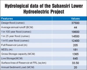
Subansiri is a major right bank tributary of the Brahmaputra river . The river originates beyond the Great Himalayan Range at an altitude of 5,340 metre. The total drainage area of the Subansiri up to the confluence with the Brahmaputra river is about 37,000 square km. The contribution of the Subansiri river is estimated to be about 10 per cent of the total discharge of the Brahmaputra river at Pandu near Guwahati. The climate in the entire region is humid. The maximum temperature is 27.3 °C and the minimum is -8 °C at Ziro. The relative humidity ranges from a maximum 94 per cent to a minimum the 62 per cent. The average annual rainfall in the Subansiri basin is 2,356 mm whereas it is 4,600 mm at Gerukamukh along the foothills. River gauges have been established since 1956 on the Subansiri river system. NHPC also established gauge and discharge (G&D) sites near the dam site and at Chouldhowaghat about 12 km downstream of the dam site which are operational since 2001. The average annual discharge at the dam site is 44,024 MCM. Floods in the Subansiri river are observed due to heavy rains in the catchment area from May to October. Maximum floods of 18,790 cumec at Chouldhowaghat (July 1972) and 13,800 cumec at Gerukamukh (2011) have been observed in the Subansiri river. The spillway design flood has been estimated using the deterministic and probabilistic approaches. The higher of the flood peak resulting from two approaches, 37,500 cumec, has been adopted as design flood. The probable maximum flood (PMF) hydrograph has been routed through a reservoir by impinging at the full reservoir level EL 205 metre and accordingly the maximum water level EL 208.25 has been arrived at. Average annual sediment load at dam site is estimated as 20 MCM based on long-term observed data.
Since the beginning of construction in 2005, the SLHEP has been facing anti-dam movements by various civic groups of Assam spearheaded by the All Assam Students Union. Due to the recommendations of the Assam Experts Group (AEG) in March 2011 against construction of the project due to its geologically and seismologically sensitive location, construction was halted in December 2011. Till then only 50 per cent work had been completed. Many hydrological/ downstream issues raised by the AEG and the National Green Tribunal (NGT) were discussed and deliberated upon by different committees formed for the SLHEP.
“The Cumulative Impact and Carrying Capacity Study of the Subansiri Sub Basin including Downstream Impacts”, conducted by the Central Water Commission (CWC) in December 2014 and accepted by the MoEF&CC, recommends the release of 240 cumec for the protection and conservation of the aquatic biodiversity of the river. One turbine of the SLHEP is proposed to run continuously to ensure a minimum release of 240 cumec. All the committees formed for the project have agreed to this. The distance between the dam toe and start of the tail race outlet (first unit) is around 250 metres only. This stretch shall always be filled with backwater when one machine runs continuously for releasing 240 cumec discharge during the lean season. Depending on the running number of turbines, 5-10 metres depth shall always be available. Therefore, the short stretch of the river from the dam toe up to the power house release point will not be dry at any point of time.
The SLHEP is envisaged as a peaking power station producing 2,000 MW of power for a minimum four hours daily in a year with 90 per cent dependable flow. Peaking power operations result in diurnal variations in the downstream flow. Peaking discharge gets moderated over time along the river due to valley storage and stream routing progressively. The maximum peaking discharge is only 2,579 cumec in the lean season at the dam site, which further reduces as it approaches downstream. Thus, the lean season flow will have much lesser velocity to have any impact on erosion of the riverbanks in comparison to the monsoon season discharge/velocity. Based on the findings of different studies/reports, there is no significant impact anticipated in the downstream or the Majuli Island due to fluctuation of water. Protection measures have been adopted up to 30 km as per the Thatte and Reddy Committee suggestions. NHPC is taking necessary measures in association with the water resources department of Assam to protect the river banks in 30 km stretch downstream of dam. The Thatte and Reddy Committee in its report mentioned, “It is seen from the routing of peaking discharges through the river that by the time Subansiri approaches Majuli, the flow gets steady and there will be hardly any noticeable fluctuations.” The committee further stated, “The SLHEP will only attenuate the floods. Majuli bank erosion cannot be attributed to floods on account of the SLHEP. The fluctuations on account of peaking mode of operation do not carry up to Majuli. They die down in the river stretch of about 30 km from the SLHEP due to valley storage”. Design flood for the SLHEP is PMF as per codal requirement for dam safety. As per IS 4,410, “PMF is defined as that flood which is estimated to result if the most critical combination of severe meteorological and hydrologic conditions considered reasonably possible in the region were to occur.” The design flood has been estimated by both a probabilistic and deterministic approach, and a higher design flood value of 37,500 cumec of the two methods has been adopted. All committees agreed that design flood estimation is in order and spillways are adequately sized. The present planning of the SLHEP includes the flood control aspect in conjunction with the Subansiri Upper and Subansiri Middle projects. Significant flood moderation can be achieved by all these three projects, that is, Subansiri Lower HEP, Subansiri Middle HEP and Subansiri Upper HEP. The flood control aspect was planned for the project during the detailed project report stage. For the purpose of flood moderation, the reservoir level of the SLHEP shall be kept at EL 190 metres, that is, 15 metres below the full reservoir level (EL 205 metres) during most of the monsoon period with a storage of 442 mcm. This will cause regulated flow in the downstream for medium floods. The reduction in medium floods (10-100 years return period floods) shall be 30-40 per cent. Annual sediment load at the Subansiri Lower dam site is 20 mcm. During the flood season, the sediment inflow in Subansiri is about 85 per cent of the annual sediment load. By keeping the spillway crest at a low level (El 145 metres) and maintaining a lower reservoir level during most of the monsoon, the sediment transport capacity will be enhanced and will not allow the major portion of the incoming sediment to settle down.
All the opinions expressed by the experts indicate that by the time the dam becomes operational, a stable sediment regime similar to the original natural condition will be reinstated. The Thatte and Reddy Committee in its report agreed that, “There is no good enough reason for the downstream to be concerned. Sluice spillway as provided in the SLHEP is in accordance with the best international practice for sediment control. Since the dam will arrest only bed load, besides a very small part of suspended load, no problem is envisaged on the downstream of dam on account of sediment transport.”
Flood forecasting in a river basin is a specialised field. The CWC along with the Indian Meteorological Department (IMD) conducts flood forecasting in river basins. Accordingly, NHPC took up the matter with the director general, IMD and member (RM) CWC. On the persuasion of NHPC, flood forecasting for the Subansiri basin was included in the 12th Five Year Plan. Flood forecasting for the SLHEP is operational since 2017. Advisory for inflow forecast of five days with a time series of river discharge is issued by the CWC during monsoon. The early warning system (EWS) has been implemented; it comprises an automatic water level recorder with auto transmission facility/telemetry at Tamen (about 73 km u/s of the dam site on the Kamla river), and at Daporijo (about 70 km u/s of the dam site on the Subansiri river). These stations give about six hours lead time. The river inflow at upstream G&D sites Daporijo and Tamen and at the SLHEP dam site is being monitored 24×7 at the EWS master control room, Faridabad. The flood forecast by the CWC at the SLHEP dam and rainfall forecast by IMD, JAXA and MOSDAC are also being monitored continuously by NHPC.
A reservoir operation manual is developed for all NHPC projects/power stations on the basis of predominant and expected discharges, taking cognisance of the actual discharging capacity of the spillway bays that is obtained generally through physical model studies. This manual contains the elaborate gate operation protocol for any given inflows in the reservoir. The step-wise operation of gates is given in an easy-to-read table. This process of gate operation for managing the floods is in practice by NHPC in all of its projects, ranging from a 25 metre high barrage to a 140 metre high dam, and has stood the test of time. The reservoir level is monitored closely at regular intervals, that is, hourly or even less than hourly basis, during the flood season. Water level recorders are installed at all the intakes and at the extreme spillway bays to monitor the reservoir levels accurately.
The central government constituted several expert committees to examine the recommendations of the AEG. A technical expert committee constituted by the Planning Commission with hydrology experts C.D. Thatte and M.S. In July 2012, Reddy allayed the concerns of the AEG related to hydrology and recommended an independent dam design review panel (DDRP) to review dam design features keeping in view the suspected foundation competency. In June 2013, the DDRP recommended a few modifications in design for additional safety of the dam. The increase in dam width from 171 metres to 271 metres, extension of upstream concrete cut-off wall and additional wall in downstream to stop any seepage to dam foundation, grouting in dam foundation, provision for rock anchor and cable tendon for stabilising abutments were the key recommendations. The National Committee for Seismic Design Parameter reviewed the seismic design parameters. However, the AEG raised concerns regarding seismological issues. In January 2015, the central government constituted the Project Oversight Committee (POC) to examine issues raised by the AEG. The POC members agreed that the reduction in dam height as proposed by the AEG was not possible with PMF considerations, essential for dam safety. It would reduce or eliminate its 15 metre flood cushion. The Thatte and Reddy Committee cited, “Agitation against the dam and demand for flood control are self-contradictory. There cannot be any flood control without a dam.” It was difficult to understand the agitation against dams, so long as they were designed with state-of-the-art procedures. It said that 240 cumec environmental flow would be maintained by running one turbine continuously to ensure sustenance of aquatic life. There would be no significant impact in downstream due to fluctuation of water level during peaking. It further stated that establishment of an independent authority for reservoir control would eliminate any probabilities of panic-release and dam-induced flood in the downstream. Downstream river protection up to 30 km and development schemes worth Rs 658 crore have been taken up. The POC agreed that the revised dam design would adequately address the dam safety issues. Ho-wever, the POC (Assam) could not concur on seismic design parameters despite endorsement from national earthquake experts.
According to the Thatte and Reddy Committee, “The opposition to the construction of a dam usually comes from displaced people, and forest and wildlife conservationists. There has hardly ever been opposition from people living in the downstream. In fact, they are the beneficiaries while the displaced people are the adversely affected people. Stating the beneficial impacts of the SLHEP in the downstream, namely, flood control, irrigation, employment, health, education, industries, trade, electricity, infrastructure development, tourism, etc., Thatte & Reddy said, “The government of Assam and the majority of local population are aware of these benefits. That is why the AEG is not really objecting to the dam. The AEG and the local people want not only a dam, but a safe dam. That is what NHPC will build, taking into account various recommendations made in the report.”
The disputes had been shifted to the Hon’ble Court as two social activists approached the NGT. In pursuance of the October 2017 judgement of the NGT for resolving various issues, the MoEFCC constituted a three-member expert committee comprising experts from the fields of hydrology, geology and seismic field. After visiting Subansiri Lower and the nearby Ranganadi and Pare projects, and having in-depth discussions with several independent experts, the committee submitted its report in March 2019. It concluded that “downstream issues such as maintenance of continuous minimum flow for sustenance of flora and fauna, flood control and flood forecasting mechanism, sediment management, protection of Subansiri banks, provision of social security to the riparian population, and dam-break analysis have been taken care of as per the recommendations of various committees”. Reviewing the reports of various expert groups related to foundation competency, slope stability, seismotectonic-seismic design parameters, dam design and downstream impacts of the project, the committee opined, “The SLHEP has been designed for expected extreme conditions and all the concerns have been adequately addressed to the extent practically feasible.”
“The Eastern Himalaya holds enormous hydropower potential, the harnessing of which can usher in rapid overall growth in Northeast, in particular. The commissioning of the Subansiri Lower Project will not only prove to be a boon for the people of the region but also open the gates for accelerated development of hydro projects in the entire Brahmaputra basin.” The NGT pronounced its final judgement on July 31, 2019 allaying all concerns on dam safety and adverse downstream impacts. Construction resumed in October 2019 after eight years, with all modifications as recommended by the committees. Till October 2022, 85 per cent work on the project had been completed.